Oddly enough, I find being able to put a name to the sense of loss and grief I feel at what is happening to our beloved area of Tikorangi is helpful. Solastalgia – the distress that is produced by environmental change impacting on people while they are directly connected to their home environment. Faced by the high impact of petrochemical development around us on every side, I now refer to the Tikorangi Gaslands. The tragedy is that it is not a joke.
 This is what our corner of Otaraoa and Tikorangi Roads used to look like in the mid 1990s. The havoc on the left hand side is the result of major work Mark carried out to reduce flooding through our park and to return some of the stream to its original bed. His tidy grandfather had straightened up the stream to run along the boundary back around the early 1900s.
 A year or two later and our children are getting off the school bus on what was a quiet country road. Note the trees on the right hand side.
 This is what our side of the road looks like now. The trees have grown up and many people tell us how much they enjoy the flowering.
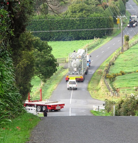
 But we now have the petrochemical industry all round us and down this formerly quiet little country lane is the huge Mangahewa C site with its eight gas wells, single men’s camp and much additional activity. The road has been strengthened and widened for their heavy transport, all done in such a way as it is now impossible to walk along the verge. It is sometimes referred to as “loss of rural amenity”. Children can no longer walk safely to and from school bus stops, cycling is not safe, forget horse riding. It is pretty difficult to find a safe position to stand clear when the heavy transport thunders by. Meantime, across the intersection, the other side of Tikorangi Road – largely unused by the petrochemical industry – has remained unchanged over the past 20 years. It is a stark contrast.
 And on the right hand side of the road where there used to be trees, there is now a green wasteland dominated by the designated high tension power lines that Todd Energy, a petrochemical company, deemed necessary for their operations. Sadly, petrochemical development is now given precedence over rural amenity, local residents or the preservation of the environment. This is our world of 2014. During the day we listen to the heavy transport. At night, our formerly pitch black sky is often lit by gas flares in one or more quadrants. On an otherwise quiet Sunday morning today, I could hear the distant noise from Mangahewa E site. Every night we go to sleep to a low drone from one of the plants and we are not even sure which one it is any longer because there are four possible sources for the noise. But under the Resource Management Act, we are told by our councils that “effects are less than minor” and we are not, therefore, an affected party.
No wonder some of us feel grief for what we have lost. Solastalgia.


 We protested modern road design with such step sides that nobody can ever pull to the side let alone walk, cycle or ride a horse alongside. We see this as a major loss of rural amenity.
 We tabled a concern that this type of hostile road design is incompatible with these roads being part of a designated cycle route. There is nowhere for bikes to go when challenged by frequent heavy transport.
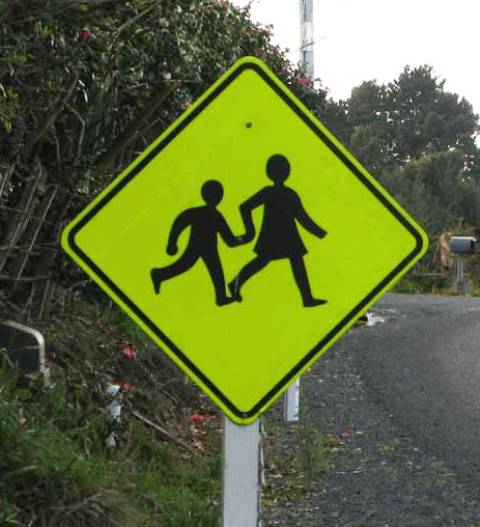 We asked that Council make every sign count. We have so many signs and road cones now that few people take notice. Children crossing signs where locals know no children have lived for decades, horse signs (above) where no horses can be ridden any longer and ever more company signs.


 Oh there have been some jokes. Shame the newspaper photographer didn’t stick around to snap these men with a petrochemical tanker and trailer unit bearing down on them at speed from behind, more than one person said. Where are their banjos and rifles, another quipped. Goodness, even Jed Clampett and the Beverley Hillbillies have been mentioned. But what on earth made these men think it was all right to attempt to discredit me, then get into their vehicles to drive down and pose outside Mark’s and my place, resembling a Wild West posse? I can only assume they meant to look intimidating and confrontational when all they had to do was to pick up the phone and ask a few questions.


 This is Kowhai C site as seen from Mangahewa E site. These sites belong to two different companies drilling right on their boundary which happens to cut through Tikorangi.
 Here we have Kowhai C site – the one this community said it didn’t want but got anyway. This photo was taken 150 metres to the side of Kowhai B site in order to get a clear view. Both sites belong to the same company – Greymouth Petroleum. Kowhai B is consented for 8 wells. Only one has been drilled so far. Close by, so very close that one wonders why the company needed a second site, Kowhai C is consented for 4 wells.
 Kowhai C again, this time from Otaraoa Road. It is one of about 10 well sites Greymouth Petroleum has in Tikorangi. I know of 9 that have been consented – I am not sure of the current status of Urenui A (which is not in Urenui but is in Tikorangi).
 This photo taken about August last year – the rig has now gone but it was on Mangahewa C, as photographed from Kowhai C. It is like a quadrilateral of sites, already. These two belong to separate companies again.
 Mangahewa E site from Stockman Road (near Mangahewa C site). These two Mangahewa sites are Todd Energy’s but, to be fair, it should be pointed out that Mangahewa C site has 8 wells drilled on it so is at capacity on its current consent.
 Work progresses on the new Mangahewa E site.
 Mangahewa E site again. It is often stated that this petrochemical development (still called “exploration” but they are long past exploration in Tikorangi where it is decades since a dry well was drilled) is “temporary”. Does this look temporary? How can these developments be temporary when the majority of consents are open ended with no expiry date? Only the most recent three sites have a time limit on the consents – 15, 20 and 30 years. In whose books is this “temporary”?
 And work progresses on extensions at Turangi A site. These are the other company’s sites (Greymouth Petroleum).
 But wait, there are more. Turangi C site is, according to the company (Greymouth Petroleum) “about” 850 metres from Turangi A site. It can’t be any more than that from Turangi B site, in that case, because it is pretty much set back between the two. Neither Turangi A nor Turangi B have been drilled to capacity. So why does the company need a third site and could they not have deviation drilled from one of the other two sites? Who knows? Only the company and neither New Plymouth District Council nor Taranaki Regional Council seem inclined to ask them why. It looks mighty like speculative consenting to some of us – described by the company rep to me as “future proofing”. Right-o then. That is future proofing the company, not Tikorangi.
 And Kowhai B site with one hole drilled, as viewed from the neighbour’s property. It doesn’t look “temporary” and it was anything but silent on the day I took this photo. It has a significant impact on the neighbour’s adjoining paddock and could well affect his future property options but he was never deemed an “affected party”. I think, to the right of centre at the front of the photo, that is an example of the screen planting done by the company. It’ll be quite a few years before anything is screened by that sort of planting.